'Twas the night before Christmas, and out on the ramp,
Not an airplane was stirring, not even a Champ.
The aircraft were fastened to tiedowns with care,
In hopes that come morning, they all would be there.
The fuel trucks were nestled, all snug in their spots,
With gusts from two-forty at 39 knots.
I slumped at the fuel desk, now finally caught up,
And settled down comfortably, resting my butt.
When the radio lit up with noise and with chatter,
I turned up the scanner to see what was the matter.
A voice clearly heard over static and snow,
Called for clearance to land at the airport below.
He barked his transmission so lively and quick,
I'd have sworn that the call sign he used was "St. Nick".
I ran to the panel to turn up the lights,
The better to welcome this magical flight.
He called his position, no room for denial,
"St. Nicholas One, turnin' left onto final."
And what to my wondering eyes should appear,
But a Rutan-built sleigh, with eight Rotax Reindeer!
With vectors to final, down the glideslope he came,
As he passed all fixes, he called them by name:
"Now Ringo! Now Tolga! Now Trini and Bacun!
On Comet! On Cupid!" What pills was he takin'?
While controllers were sittin', and scratchin' their head,
They phoned to my office, and I heard it with dread,
The message they left was both urgent and dour:
"When Santa pulls in, have him please call the tower."
He landed like silk, with the sled runners sparking,
Then I heard "Left at Charlie," and "Taxi to parking."
He slowed to a taxi, turned off of three-oh
And stopped on the ramp with a "Ho, ho-ho-ho. "
He stepped out of the sleigh, but before he could talk,
I ran out to meet him with my best set of chocks.
His red helmet and goggles were covered with frost
And his beard was all blackened from Reindeer exhaust.
His breath smelled like peppermint, gone slightly stale,
And he puffed on a pipe, but he didn't inhale.
His cheeks were all rosy and jiggled like jelly,
His boots were as black as a cropduster's belly.
He was chubby and plump, in his suit of bright red,
And he asked me to "fill it, with hundred low-lead."
He came dashing in from the snow-covered pump,
I knew he was anxious for drainin' the sump.
I spoke not a word, but went straight to my work,
And I filled up the sleigh, but I spilled like a jerk.
He came out of the restroom, and sighed in relief,
Then he picked up a phone for a Flight Service brief.
And I thought as he silently scribed in his log,
These reindeer could land in an eighth-mile fog.
He completed his pre-flight, from the front to the rear,
Then he put on his headset, and I heard him yell, "Clear!"
And laying a finger on his push-to-talk,
He called up the tower for clearance and squawk.
"Take taxiway Charlie, the southbound direction,
Turn right three-two-zero at pilot's discretion"
He sped down the runway, the best of the best,
"Your traffic's a Grumman, inbound from the west."
Then I heard him proclaim, as he climbed thru the night,
"Merry Christmas to all! I have traffic in sight."
Anonymous
Monday, December 20, 2004
Sunday, December 12, 2004
High Flight
A posting to rec.aviation.piloting noted the following.
This was the first time I've heard of John Gillespie Magee, Jr. or of the poem "High Flight", fortunately it was also a part of the post.
High Flight
by John Gillespie Magee, Jr.
Oh, I have slipped the surly bonds of earth
and danced the skies on laughter-silvered wings;
sunward I've climbed, and joined the tumbling mirth
of sun-split clouds - and done a hundred things
you have not dreamed of - wheeled and soared and swung
hung in the sunlit silence. Hov'ring there,
I've chased the shouting wind along, and flung
my eager craft through footless halls of air.
Up, up the long, delirious burning blue
I've topped the windswept heights with easy grace
where never lark, or even eagle flew.
And, while with silent, lifting mind I've trod
the high untrespassed sanctity of space,
put out my hand, and touched the face of God.
"On September 3rd, 1940, Pilot Officer John Gillespie Magee, Jr., wrote his now famous poem "High Flight" while training with the RCAF. A scant 3 months later, on December 11th, 1940, he was killed while flying a Spitfire in the war-torn skies of England. He was 19 years old."
This was the first time I've heard of John Gillespie Magee, Jr. or of the poem "High Flight", fortunately it was also a part of the post.
High Flight
by John Gillespie Magee, Jr.
Oh, I have slipped the surly bonds of earth
and danced the skies on laughter-silvered wings;
sunward I've climbed, and joined the tumbling mirth
of sun-split clouds - and done a hundred things
you have not dreamed of - wheeled and soared and swung
hung in the sunlit silence. Hov'ring there,
I've chased the shouting wind along, and flung
my eager craft through footless halls of air.
Up, up the long, delirious burning blue
I've topped the windswept heights with easy grace
where never lark, or even eagle flew.
And, while with silent, lifting mind I've trod
the high untrespassed sanctity of space,
put out my hand, and touched the face of God.
Saturday, December 04, 2004
Abandoned & little known airfields
Interesting site of closed or little know airfeilds, alot have very interesting histories.
http://members.tripod.com/airfields_freeman/index.htm
http://members.tripod.com/airfields_freeman/index.htm
Santa's Sleigh on ASO
It's a pretty sweet ride, especially with the upgraded Claus II Nav package.
http://www.aso.com/i.aso3/aircraft_view.jsp?aircraft_id=86820
http://www.aso.com/i.aso3/aircraft_view.jsp?aircraft_id=86820
Saturday, November 20, 2004


Flight planning and navigation with Keyhole
Other than flying airplanes, I'm your basic mid-twenties computer junkie. I've always been a fan of Google, not only for their search engine technology but as a company not only sees the future of the Internet, but actually does something to make that happen.
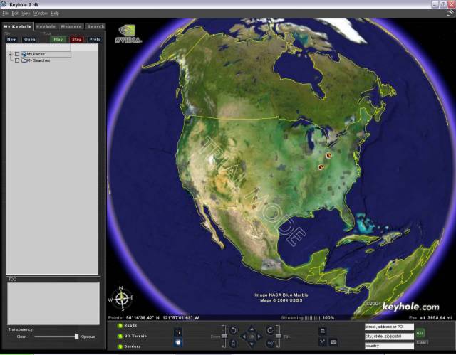
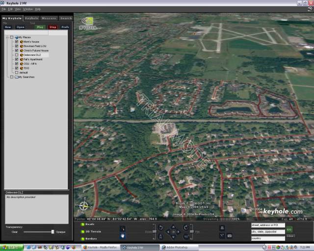
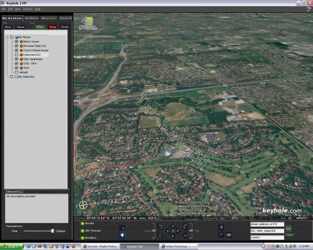
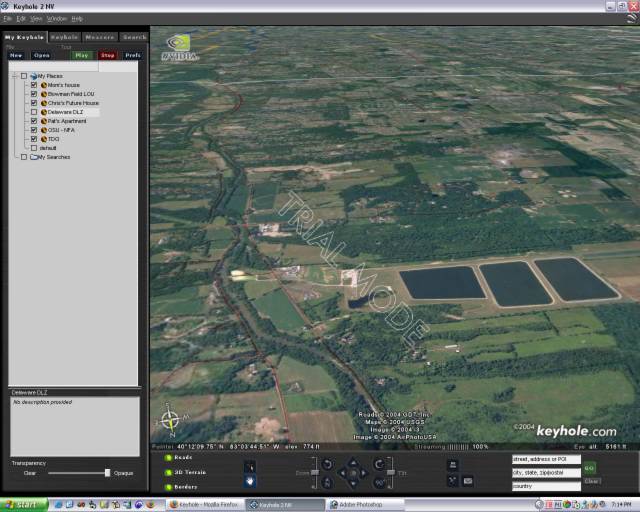
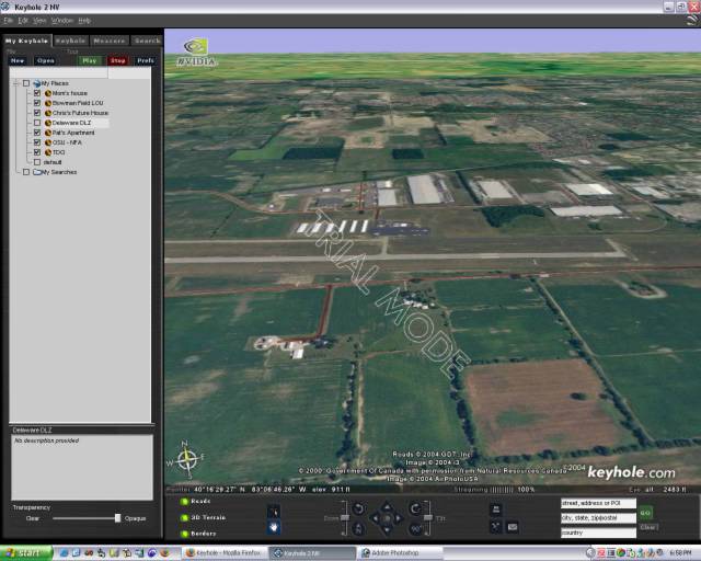
Recently they acquisitioned a software product called Keyhole, which they announced this week in their typical manner with a low-key link at the bottom of their main page. To describe Keyhole, it's a streaming source for high resolution satellite images from all over the planet. In cities where they're highest resolution is available (such as Columbus OH) you can zoom in down to street level with an amazing level of detail.
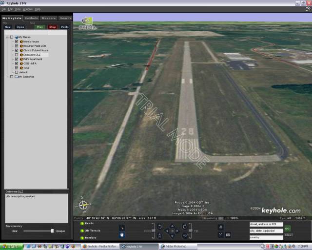
That sounds pretty neat, but what does it have to do with aviation? Well, choosing checkpoints on a sectional chart is one thing, but finding the checkpoint up in the air is a whole different manner, especially if it's the first time you're actually flying in the area. Keyhole enables you to actually see what the lake or town you'll fly near will look like. Using the tilt and rotation controls you can even position the view to show you what it'll look like from the direction you'll be flying from.
This type of visualization is critical. Finding the checkpoint is important, but as I learned recently from my last trip to Louisville, the relationship between your plane and the checkpoint you reach is vital in determining whether or not you're blowing off course.
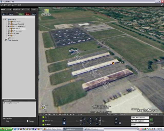
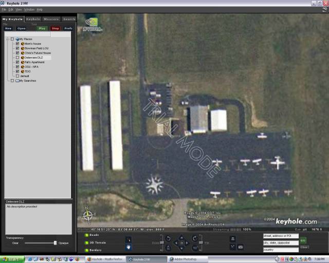
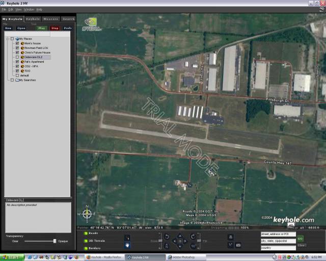
Keyhole also plays and important role in finding an airport. Airport and taxiway diagrams (assuming one is available for your destination, for many small fields there are not) can help you in figuring out runway lengths and orientation, available taxiways and such, but they cannot prepare you for what the airport will visually look like from your direction of flight. My first instructor told me that the second biggest lie in aviation is "I have the field." Well, using Keyhole you can prepare yourself by identifying visual cues that will help you quickly identify the field when you're in the sky.
Finally, to take it to the next step you can also virtually fly your entire flight plan from Keyhole. Pick your homefield and your destination and record the trip like a movie for later playback and study.
There are some limitations though, the highest "right-down to the street" resolution imagery is only available in certain cities, although they seem to be expanding the list like crazy, and there are a lot of areas that are "green zones" which only have terrain, road and river details, which is more like a visual rep of a sectional chart. In addition, the images aren't real time (of course) and there's a question of how recent the images are. For instance, a shot of Delaware's field (DLZ) showed where they recently repaved a taxiway, however when I looked up my friend Chris' house it just showed me an empty lot before they began construction.
These improvements are coming though, and it's going to happen soon. The applications for this technology are huge, although I think aviation has the most to gain from this, especially GA. Combine this with the GPS units and MFDs already being added to new GA aircraft, the availability of cheap and high quality flight planning (with real-time weather) software and the continued expansion of high-speed internet access, the information divide that separated the private pilot and the airline pilot previously is going to be a thing of the past.
A free trial of Keyhole is available for download at their website (http://www.keyhole.com). The free trial for the personal edition is 7-days, with a year subscription running $29. They also have a version for nVidia enabled graphic cards.
Clear skies!
Recently they acquisitioned a software product called Keyhole, which they announced this week in their typical manner with a low-key link at the bottom of their main page. To describe Keyhole, it's a streaming source for high resolution satellite images from all over the planet. In cities where they're highest resolution is available (such as Columbus OH) you can zoom in down to street level with an amazing level of detail.
That sounds pretty neat, but what does it have to do with aviation? Well, choosing checkpoints on a sectional chart is one thing, but finding the checkpoint up in the air is a whole different manner, especially if it's the first time you're actually flying in the area. Keyhole enables you to actually see what the lake or town you'll fly near will look like. Using the tilt and rotation controls you can even position the view to show you what it'll look like from the direction you'll be flying from.
This type of visualization is critical. Finding the checkpoint is important, but as I learned recently from my last trip to Louisville, the relationship between your plane and the checkpoint you reach is vital in determining whether or not you're blowing off course.
Keyhole also plays and important role in finding an airport. Airport and taxiway diagrams (assuming one is available for your destination, for many small fields there are not) can help you in figuring out runway lengths and orientation, available taxiways and such, but they cannot prepare you for what the airport will visually look like from your direction of flight. My first instructor told me that the second biggest lie in aviation is "I have the field." Well, using Keyhole you can prepare yourself by identifying visual cues that will help you quickly identify the field when you're in the sky.
Finally, to take it to the next step you can also virtually fly your entire flight plan from Keyhole. Pick your homefield and your destination and record the trip like a movie for later playback and study.
There are some limitations though, the highest "right-down to the street" resolution imagery is only available in certain cities, although they seem to be expanding the list like crazy, and there are a lot of areas that are "green zones" which only have terrain, road and river details, which is more like a visual rep of a sectional chart. In addition, the images aren't real time (of course) and there's a question of how recent the images are. For instance, a shot of Delaware's field (DLZ) showed where they recently repaved a taxiway, however when I looked up my friend Chris' house it just showed me an empty lot before they began construction.
These improvements are coming though, and it's going to happen soon. The applications for this technology are huge, although I think aviation has the most to gain from this, especially GA. Combine this with the GPS units and MFDs already being added to new GA aircraft, the availability of cheap and high quality flight planning (with real-time weather) software and the continued expansion of high-speed internet access, the information divide that separated the private pilot and the airline pilot previously is going to be a thing of the past.
A free trial of Keyhole is available for download at their website (http://www.keyhole.com). The free trial for the personal edition is 7-days, with a year subscription running $29. They also have a version for nVidia enabled graphic cards.
Clear skies!
Saturday, November 06, 2004


Subscribe to:
Posts (Atom)
